


Adventures of Avalon Part 2
- David Kilby

- Aug 11, 2019
- 28 min read
In this second part of my Adventures of Avalon blog, we leave the marina and begin our trek down the East Coast.
Thursday, April 11, 2013
We left at about 7 a.m. this morning with the sunrise behind us, navigated through some early fog and had mostly clear skies all the way down to our Day 1 anchorage spot, Minim Creek, about 60 miles down the Intracoastal Waterway from Barefoot Marina. So, we’re finally underway.
Minim Creek is a very secluded area with the only sign of civilization being the flashing red marker on the ICW about a half mile away. The creek is the ideal spot to drop anchor off the waterway. The area we’re in is protected from the winds by trees on both sides, and the depth is about ten feet. While we were looking for just the right spot to end our day, a pod of dolphins swam around our boat. One actually came right next to the bow as we were getting ready to drop anchor. While en route to our destination, about 20 miles from Barefoot Marina, we saw two swans swim right by the boat and then come together to touch beaks, their necks and beaks thereby forming the shape of a heart. It was a sight for our weary eyes as we were just starting to really wake up.
The wind was at between 15 to 20 knots for most of the way, but around Georgetown, SC the ocean's current increased our speed by about 2 knots, bringing us up to 10 at times when we only set the throttle at 8 knots. So we cruised about 60 miles in approximately 7 hours, arriving at Minim Creek at 2 p.m. It’s been a long day and we’re running on generator power, so I have to log off now.
Keep following our travels. We feel as if you’re cruising with us.
Tomorrow's destination is Charleston, about 50 miles away. The distance is shorter than today's but the weather is expected to be a bit stormy tomorrow, so that will probably slow us down a bit.
Images from Day 1


Friday, April 12, 2013
A thunderstorm passed through last night and the sky was overcast most of the day, with winds gusting up to 30 knots. The weather made us hesitate leaving Minim Creek, but we took the risk and headed for Charleston at about 11 a.m. When we left we had the whole waterway to ourselves for miles, that is if you don’t count the pelicans and cormorants flying around our boat, and the dolphins swimming all around us. There were dolphins everywhere today due to our closer vicinity to ocean inlets. We saw at least a dozen on the waterway, and never got tired of seeing them.
With perpetual high winds we passed the small fishing village of McClelanville, another small seaside village called Andersonville and the Isle of Palms, a resort island between the waterway and the ocean.
Towards the end of the day we arrived at Charleston Harbor. Even though it seemed easy to navigate on the charts we studied, it actually wound up being the most difficult part of the trip so far. The vastness of the harbor is immediately misleading, because there are sandbars to the right as soon as you enter from the north. Also, the ICW markers on the harbor are few and far between, and they're mixed in with quite a few other markers indicating a route out to the ocean. The current and high winds from the ocean also add to this obstacle course to Charleston. Barges coming in and out of the international port just add to the challenge. One did in fact pass right in front of us as we crossed the harbor.
We got to our destination, Charleston City Marina, at a reasonable time, about 6:30 p.m. The marina has everything we need, so although we may not have the remote quietness we had last night, we are enjoying many more conveniences, like shore power and bathroom facilities. If you want to know how the rich live, just take a stroll down the mega dock of this marina, where all kinds of mega yachts are docked. The pleasure boats make 46-foot Avalon look like a humble dinghy. Dolphins seem to like it here too. In fact I just saw another inside the marina.
I've always heard that Charleston, SC is among the most beautiful cities in the country. The so called "Holy City" with church steeples dominating its skyline seemed to call out from across the harbor as soon as our naked eyes could see it through the grey sky. We will have a pleasant short stay here tomorrow and will leave for Beufort/Port Royal late tomorrow morning.
Saturday, April 13, 2013
The route today was filled with southern plantation homes and docks along the waterway and wide open rivers, as well as some narrow creeks and man made cutoffs. We're now anchored at Upper Rock Creek, about 45 miles down the ICW from Charleston. Like Minim Creek, it's a very remote spot with nothing but marsh all around us. The view of the night sky is majestic, and could even compare to the northern lights they said appeared over New Jersey this evening.
The water around us is between nine to 12 feet, and the marshy shore is about 100 feet away on either side. We were going to go up the creek to deeper water, but the low tide revealed a sandbar that was too large to risk navigating past. After settling in, another dolphin passed right by our boat, and later a small boat with about five people on it passed from up the creek. That seems to be a common sight around here, as are the dolphins.
Being in the middle of nowhere doesn't mean we can't have modern conveniences though. For dinner Captain Ken cooked up pasta with meat sauce, and we watched Raiders of the Lost Arc with power from the generator. We have the peace and quiet of camping with the creature comforts of our own home.
Tomorrow we will cruise past Beufort and Port Royal, SC before crossing the Georgia border. We don't know exactly where we'll anchor or when we'll settle in because another storm is forecast for the evening tomorrow. The idea is to be settled in well before that.
Sunday, April 14, 2013
We started cruising at 7:40 a.m. today and went about 85 miles on the ICW from Upper Rock Creek, SC to Possum Point, GA, just outside Vernon View. It was raining about half of the day, toward the late afternoon, and we anchored at about 5 p.m. just before it started to thunderstorm. Possum Point is a peaceful anchorage with Vernon View, a suburb of Savannah, on the eastern shore.
We passed Parris Island and Hilton Head, SC in the afternoon. The islands are fairly close to each other, but are complete opposites, and have no connection to Paris Hilton, as far as I know. Parris Island, as many know, is the recruiting center for the U.S. Marines, and Hilton Head is a wealthy resort area with world renown golf courses, like Spanish Wells and Harbour Town, and celebrities. My dad trained as a Marine at Parris Island, and as we passed the island Uncle Ken told me stories about visiting him there, and other stories about the harshness of platoon leaders in the 1960s. The island seems drenched with hard times, and has its own potent character that stands out in the middle of the otherwise placid, historically hospitable South Carolina Low Country region.
After passing the Georgia border, we soon encountered a barge while crossing the Savannah River. It looked like we were on a collision course with it, so we turned around quickly to give it room to pass us, then continued to cross the river. It was fascinating to see the barge up so close, but frightening when considering the danger of being so close to such a large vessel on such a big river.
We've passed several quaint towns like McClelanville, Andersonville and Beufort, SC, as well as Isle of Hope and Vernon View, GA. We stopped at Charleston a few days ago as well. The city marina of this southern gem, the Holy City, was the only marina we've stayed at so far.
Monday, April 15, 2013
Today's leg of our journey took us through perhaps the two toughest parts of the ICW: Hell Gate and Jekyll Creek, Georgia. After leaving last night's anchorage on the Vernon River, we luckily reached Hell Gate at high tide. The small cut links two huge sounds right by the ocean, and the water is only five feet deep in places. To avoid the shoaling on either side of the narrow cut, you have to zigzag and squeeze between several markers while staying at a relatively low speed, since a boat draws less water when going slow. At the same time though, you have to maintain a fast enough speed to fight the currents. After we passed through with some difficulty, we noticed how appropriately named Hell Gate was.
We then safely passed through most of the major sounds of Georgia, including St. Catherines Sound, Sepolo Sound, Altamaha Sound, Saint Simons, and Jekyll Sound. Before Jekyll Sound though, we came to sneaky little Jekyll Creek at low tide. The water was never deeper than 13 feet, and the creek itself was never wider than probably 100 feet as we navigated down it.
Just before Saint Simons Sound, two dolphins came and swam beside our boat. We've been trying to get good pictures of at least a few dolphins, but this close and long encounter gave us the chance to take a video. If I don't post it today I will tomorrow.
We found a beautiful anchorage across the Jekyll Sound, called Umbrella Creek. It's surrounded by vast expanses of marshland and has the ocean just off in the distance; serene seclusion.
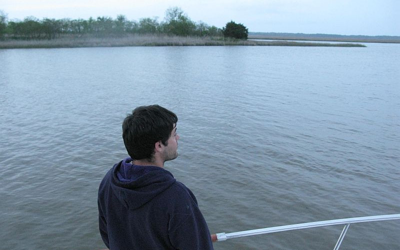
So in all today we cruised from 8:15 am to 6 pm, covering about 85 miles. Tomorrow we'll be entering Florida, which is about 30 miles away. At this rate we should be in Miami in about five days. From there we will cross over to The Bahamas as soon the weather permits. Here are some photos from the past few days. All are by Captain Ken, except the pelican (which I took).


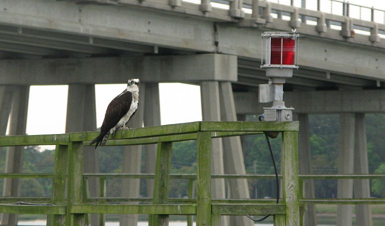


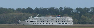

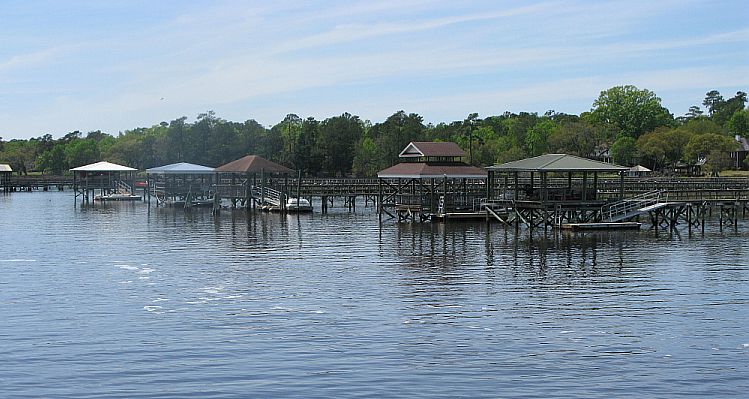
The first image is a southern mansion in Isle of Hope, GA. The second one is of an osprey on Port Royal, SC Bridge. The third is a pelican in central SC. The fourth is Parris Island. The fifth is me chillin' with Tostitos and a Corona after an 85-mile day. The sixth is American Cruise Lines' American Star anchored in central Georgia marshes 4/15. We've been playing tag with her down the coast since she left from Charleston, SC. The seventh image is of the docks at Isle of Hope.
Tuesday, April 16, 2013
Today had a number of memorable sights ranging from wild horses to top secret Navy vessels. After exiting our anchorage at Umbrella Creek, we came into St. Andrew Sound, a wide open body of water that peaks out into the ocean.
Traversing the sound was the closest we've gotten to actually going out on the ocean on our trip so far. The five miles or so of the sound had a modest chop, which was manageable but tough enough to indicate that it wouldn't be wise to go out on the ocean today. After St. Andrew Sound, we approached Cumberland Island National Seashore, home to loggerhead sea turtles, hogs, armadillos and horses. Rumor has it that generations ago, when the caretaker of the horses died, she specified in her will that her horses be allowed to freely roam on 9,800 acres of government-protected wilderness on the island.

As usual, but still not to be taken for granted, pods of dolphins swam all around our boat today, especially up the St. Johns River to Jacksonville, where we're now docked. As I promised, here's the video of a few of the bottle nose dolphins riding our port side waves. Perhaps the most startling sight of our trip so far came in Kings Bay, Georgia, near the Kings Bay Naval Submarine Base. As we passed the base, a Navy security patrol rode beside us carefully monitoring our movement. I thought his concern was a little over the top, that is until we saw what was coming ahead of us just peaking out over the top of the water: a Trident submarine, a boomer, headed right toward us. They hailed us on the radio and told us to move out of the channel and stay 500 yards away from the sub.

I don't know how often these giants come through the waterway, but every boat we heard on our radio seemed to be like sitting ducks, clueless as to what they should do, as the boomer approached them.
After passing Kings Bay and Cumberland Sound, we crossed the Florida-Georgia Line and approached Fernandina Beach. The city has what look and smell like wood pulp factories on either side, but despite this heavy industry the quaint city in between boasts a beautiful marina and downtown.
We went about 10 miles up the St. Johns River to dock in Jacksonville, since it offered a much wider and better selection of marinas. We're now docked at Arlington Marina just north of the city, with downtown Jacksonville in sight and just a few miles from our starboard stern. It was a short ride today in very pleasant, sunny weather with some wind, but not as bad as the first few days of our journey.

You all travel with us. May the road rise up to meet you too!
Friday, April 19, 2013
The state of Florida is beautiful, especially the coast. That's why so many people live here. That's also why they have so many restrictions on the waterway. There are no wake zones within no wake zones. There are private communities that create their own waterways off of the ICW, which are perfect places to anchor, but transients aren't allowed to anchor there, and the ICW down here needs dredging in numerous places. Today we often encountered five feet of water under our boat, which draws about three feet and ten inches.
Despite these obstacles though, we traveled 95 miles today, the farthest we've traveled yet in one day. We passed Daytona Beach and Cape Canaveral, but could't catch a glimpse of the speedway and only saw the NASA assembly building from a far off distance. Our departure point today was a small creek called Factory Creek that we got lucky finding right beside a Sea Ray factory in between St. Augustine and Palm Coast. Tomorrow we should reach Palm Shores and the next day we should come to Palm Beach. A few days back we passed Isle of Palms. Getting these towns mixed up has been common for us.
While anchored in Factory Creek we had no Internet signal from our phone's hotspots, which was strange because it was in the middle of a suburban area. We left that anchorage at sunrise and cruised down the waterway to about five or ten miles south of Cocoa, which is historically the birthplace of surfing in the U.S. That kind of follows a trend because we also passed the birthplaces of auto racing in Daytona Beach, and of the U.S. space program in Cape Canaveral, and yesterday we passed the first city established in the U.S. when passing St. Augustine.
It was tough finding an anchorage tonight because our route ended on the Indian River, which is long and wide and has just about no tributaries or creeks running off it. We're now anchored on the east side of the mile-wide river, about 200 yards from the shore, where peacocks have been screaming all evening. It's not annoying though. We've encountered plenty of terns, pelicans and cormorants, and even a few ospreys, egrets, and blue herons, but this is the first encounter we've had with peacocks on the trip.
Sunday, April 21, 2013
The water is getting bluer and it’s getting hotter as we cruise down Florida’s Gold Coast, where waterfront houses try to outdo each other in size and luxury. After a while, after passing through Jupiter and Palm Beach, and by the time we reached Boca Raton, we got tired of saying "Wow, look at that house!" because we knew five minutes later we’d be saying ‘Man, look at that house that’s even bigger.’ The over-the-top sleek yachts in this area are called things like "Sexy" and the party boats treat the ICW like a main street. Half the bridges are too low for 18-foot tall Avalon to pass under. Paddle boarders, water skiers, kayakers, and sunbathers on little boats have little concern for the speeding jet skies and sporting boats that zip by them.
It really is a different world down here, and it’s only going to get crazier when we reach Fort Lauderdale and then Miami tomorrow. I can’t even anticipate what it’s going to be like. But then again, every day seems to present new surprises, new scenery, and new challenges. Every night our anchorage has a completely different theme to it. Yesterday, we anchored right on the south side of a bridge in Stuart, and tonight we’re parked in Lake Boca Raton with pastel-colored condominiums, resorts and modern mansions all around us. When we came into the lake at about 5:15 p.m. it was packed, then the weekend boaters slowly left. Now we practically have the entire lake to ourselves with the city all around us.
We started at 8:15 a.m. today, cruised for nine hours through congested waterways, and ended our day after covering about 60 miles. The small wake zones, boat traffic and bridges slowed us down significantly. Here are some photos from recent days.


Monday, April 22, 2013
It’s a good thing we didn’t let the torrential downpour in Boca Raton keep us from moving south this morning, because if we did we then wouldn’t be relaxing in a cove off Virginia Key with Miami as a backdrop. I almost want to say we have arrived, but this is just another check point. We’ll wait here in Miami until the ocean is calm enough to cross over to The Bahamas. If it doesn’t look like a window to cross over is coming any time soon, we’ll head down to the Florida Keys instead, which isn’t too shabby of a Plan B if you ask me.
On the Gold Coast, just about every five miles there's a low bridge we had to signal or wait for before they would open. Many of the bridge tenders were easy going, accommodating people who were happy to open the bridge for us. Some of them even had a sense of humor. We heard their interactions with other boaters around us through our radio. In northern Florida there was a troller ahead of us who wasn’t sure if he could make it under one bridge, and he asked the bridge tender his opinion. The bridge tender just told him to come up closer, adding "I don’t mind opening the bridge if you think you can’t make it. I get paid to open and close the bridge. So just come on up and we’ll have a closer look." He wound up making it through okay.
In Fort Lauderdale, the bridge hailing was so commonplace that the people calling the bridges seemed to create a culture of their own with the bridge tenders. You'd think the city would be more accommodating to boaters and build bridges higher so more boats can pass underneath, considering that the city is known as the Yachting Capital of the World. But just about every minute we’d hear people requesting the next bridge’s next scheduled opening, while bridge tenders told boaters to "stay clear of the fenders" near the bridge. They won’t open, even if they’re scheduled to, unless a boat is approaching, of course. But sometimes the bridge tenders will give boaters the benefit of the doubt and prepare to open even if the captain that called them isn’t in sight. “This is Atlantic Avenue Bridge, getting ready to open for a requesting vessel,” we heard a bridge tender say on the radio. "I don’t see you, but that doesn’t mean you’re not out there somewhere."
The short conversations on the radio give us two lone stars a bit of extra company along the waterway that sometimes never seems to end. But once we hit Miami we ran into a little bit of bad company. It was nothing extreme really, but it was a little frustrating when we came to the Venetian Blvd. West Bridge just a few minutes past its scheduled opening at 1:30 p.m., and they refused to stay open for an extra two minutes for us. We had to circle around the bridge for a half hour for its next scheduled opening. All is well, though. We were making good time. By 2:30 we found our anchorage in Virginia Key. Once we were settled in we went for a swim. The light blue water seemed to wash away the long days of meandering through marshes, enduring long straightaways, choppy sounds, and congested city canals along the ICW. Yes, I know it was only about a 10 day voyage, but jumping in that water was as refreshing as seeing the ocean for the first time.


Tuesday, April 23, 2013
We’ve been listening to the reports on ocean conditions, and they say as of now the waves out there are about 10 feet. That’s not what we were hoping for. After spending the day in an anchorage off Virginia Key, we’re now planning to hop over to Dinner Key and pick up a mooring there, where ideally we’ll wait for the conditions to be right to cross over to The Bahamas. If the ocean doesn’t show us favor any time soon though, we’ll head down to the Florida Keys instead.
In the meantime, here at Virginia Key, the greatest portion of my day today was spent learning how to row Captain Ken’s dinghy to and from the shore a few hundred yards away. It was a windy day, which made it a little more difficult. After hours of struggle, getting pushed back to shore by the waves and having the rows consistently fall out of their slots, Captain Ken came out to help. A few hours later, I had another go at it and finally managed to get the dinghy going forward. Do I get a sailor’s badge or something? No, just a little more self-assurance. I have a history of learning simple things the hard way. Even as I was struggling to get off shore with the dinghy though, I could have counted my blessings because not too far from me there was a sailboat that ran aground and was in worse shape than me. It was there when we got here yesterday and stayed aground until this evening when a motor boat helped pull it out.

So here we are just off the coast of Miami waiting for the hazards of the sea to wane, and the sailboat was a reminder of how unforgiving even the calmest waters can be.
Every day continues to bring new experiences. Sometimes I think of the life I left behind in New Jersey; I’m starting to miss my friends and family. I had a pretty comfortable, secure lifestyle and steady work before I left. Everything was going smoothly. But that’s exactly what bothered me. I felt like it would all be torn from my grasp against my will, and then I’d have no idea what to do. That’s why the moment I feel too attached to something, whether it be a lifestyle or a TV show, I let it go for a while. When I come back to it, I then see it anew and appreciate it more. Every time we make a decision that could be life changing, there are things that we have to let go of. Sometimes they come back to us, sometimes they’re lost forever. Either way though, we’re a better person for it because we took a chance and expanded our hopes of what our lives could be.
Thursday, April 25, 2013
There’s a book on The Bahamas from the early 1990’s sitting on the boat. Nautical charts showing the way to little secluded islands, or cays, have teased me for months; they seemed so close yet so far away. Now, as we deal with a “sour season” for crossing over to The Bahamas, the islands seem to be drifting farther and farther away.
The 10-foot waves reported on the ocean have subsided to two to four feet, occasionally five to eight feet, but there’s still an east-northeast wind clashing with the south-flowing Gulf Stream, which makes for some really treacherous waters. It’s pretty common knowledge to most boaters to never set out to The Bahamas whenever there’s any kind of wind from the north. I can’t get around the feeling of slight disappointment, should we not get the chance to follow Plan A. Over the past few days I’ve been looking for ways to stay positive, despite this eminent change of plans.
So here's what I've gathered so far. The Florida Keys have some nice isolated isles of their own, and some really good spots for diving and snorkeling. The keys could offer everything I hoped to experience in The Bahamas. And, the keys are easier as well as cheaper to get to, considering the $300 customs fee boaters have to pay to get access to the islands of The Bahamas.
For all practical reasons, the Florida Keys are the best place for us to go right now. They’re saying it’s not a good idea to cross the Gulf Stream for at least another week. Part of me does still want to abandon all reason though, take the risk and dare the unforgiving sea. Captain Ken discourages that foolhardy notion. We could wait for a week or even more to see if the north wind changes direction, but why do that when we could be enjoying ourselves in the keys instead?
A picture over the sink in the galley has a quote on it reading, “If you’re not living on the edge, you’re taking up space." In one of my first blog posts of this voyage I played with a similar adventurous spirit quoting Spanish poet and religious sister Juana Ines de la Cruz, who said, "If men weighed the hazards of the sea, none would embark." These proverbial sayings now sound more like wishful thoughts than practical words of wisdom. In a more luck-driven world, everything would go as planned. But as things are in real life, it’s not good to keep high expectations when you’re dependent on Mother Nature and Father Time.
We've spent the past couple days in the Dinner Key mooring field just off of Coconut Grove, and a few miles southwest of our last anchorage off Virginia Key. This is the first time we've picked up a mooring ball on this voyage, and it proved to be a challenge. After circling around it about five times trying to pick it up, and struggling to keep it from under the boat, we managed to tie the mooring to the stern. But, it has to be at the bow, so we took the dinghy out to untie and retie lines until we gradually got the mooring to the front of the boat. We've been taking a boat shuttle back to land to get our land legs back for a while. Tomorrow we will get our provisions and Saturday we plan to head south for the Florida Keys, ideally John Pennekamp Coral Reef State Park, off Key Largo.
Saturday, April 27, 2013
We spent about four days in Miami and then headed south to Key Largo, about 50 miles away. After filling up with gas,we took Hawk Channel, which is the outside route to the Florida Keys right along the ocean. The waves were a bit too high and frequent for my stomach’s liking, and ... well, let’s just say the side of the boat became my good friend. By the evening though, I had practically forgotten about my seasickness, and was able to enjoy the 30-pound grouper that Captain Ken caught off the boat stern while I was driving the boat. It gave us a reason to put together the gas grill he bought. The following hour or so was spent filleting the fish. Then we nibbled on the fish fillets and “medallions” after we sprinkled them with salt and pepper. It was a five-star dinner on the open ocean, and we didn’t even have to pay a cruise ship fare. The meat should last us at least a few more meals.


So today was the first time I tasted grouper fresh from the ocean, and yesterday was the first time I saw a manatee, the cow of the sea. The sea mammal seemed to pop out of nowhere as we walked off the dinghy dock at Dinner Key Marina. It was cute and ugly at the same time, not to mention huge. Legend has it that weary sailors mistook these beasts for mermaids after months at sea.

Apparently many manatees have been run over by boaters, so there are designated manatee zones all along the Florida coast.
Today we're anchored between Rodriguez Key and Key Largo. Our destination for tomorrow will be Marathon, where we will spend a few days.
Along our route today, we passed Cape Florida on Key Biscayne and Stiltsville, an abandoned but preserved community of houses built several miles off the coast of Miami.


Sunday, April 28, 2013
The wind has been relentless over the past few days, about 20 knots on average. It has made for some really choppy seas, about four-foot waves, and tiresome traveling on the ocean. After experiencing the last two days on the open sea, not going to The Bahamas makes more sense. The waves going out there would have been at least five feet, and they'd be clashing with the Gulf Stream. Not to mention, they're calling for isolated thunderstorms for the next week. And on top of that, there's a chance we'd get stuck in The Bahamas waiting for fair weather to return.
On our way from Key Largo to Marathon today, everything from the chairs to the entertainment system were tossed around the boat. If we weren’t struggling to steer the boat with the waves, we were busy strapping things down better. Naturally, I once again got seasick. It was only a four or five hour trip from Key Largo to Marathon, but it was probably the toughest day of travel yet. We decided we’ll be taking the inside route on the way back. Right now we’re tied to a mooring in Boot Key Harbor. A few courteous boaters on a dinghy back to their boat helped us pick up the mooring by taking the first line and tying it on for us.
Once we were settled in we took a long nap since we hadn’t gotten much sleep the past three nights due to the excessive wind in Dinner Key mooring field and our Key Largo anchorage. So as enjoyable as the voyage is, it still comes with its challenges. Another challenge is keeping in mind all the new terminology that comes with living on a boat. Here’s a list of nautical terms I had to learn while at sea.
Left – Portside
Right – Starboard
Front of boat – Bow
Back of boat – Stern
Side of boat - Beam
Steering wheel – Helm
Map – Chart
Rope – Line
Shallow water – Skinny water
Island – Key or cay
Sinking – Taking on water
Filling up water tanks – Taking on water
Overturned - Capsized
Yacht – Pleasure vessel
MPH – Knots (or close to it)
Miles – Statute miles
Miles as measured on the sea – Nautical miles ( about 1.2 miles)
Kitchen – Galley
Oven/stove – Range
Window – Hatch
Bedroom – Cabin
Anchor – Windlass
Toilet – Head
Groceries – Provisions
The plan is to stay in Boot Harbor for a few days. It will be a much-needed rest considering the past few days.
Tuesday, April 30, 2013
For the past few days we’ve been in a mooring field off Boot Key in Marathon Shores. The island has the Atlantic Ocean on one side and Florida Bay, which is basically the Gulf of Mexico, on the other side. Today we walked the distance from one side to the other, about a half mile, on our way to get some lunch at Keys Fisheries. All our amenities are at Marathon City Marina, but the boat is at least a half mile from the actual marina so it’s a pretty far dinghy ride to get there. We plan to stay here for the week, and perhaps take some day trips out to some nearby coral reefs for some snorkeling and scuba diving.
The more we talk to others the more word we hear about how crazy it would be to go to The Bahamas any time soon. On our way down to the keys, we heard on the VHS radio coast guard station that three boats capsized on their way to The Bahamas. That could have been us if we decided to go east across the Gulf Stream in these kinds of winds, which have continued to be around 20 knots. We got thrown around pretty bad on the boat just going south via Hawk Channel.
Be that as it may, I keep hearing people say “the boat can take more than you can.” That’s understandable, considering I got green in the face from just four-foot waves while the boat seemed to just be in its element. It was made for stuff like that. As the expression goes, "Harbors are safe places for ships, but ships weren’t made for harbors." So the other side of me will always say, heck if Avalon could have made it to The Bahamas so could have I; even if I would have been spending half the voyage with my head hanging over the side of the boat.
Those who do plan to go to The Bahamas, even the most experienced captains here, are waiting about a month for the conditions to be right. Unfortunately we don’t have that kind of time. I need to be back for business reasons, and the boat needs to be north of Florida by June for insurance reasons since that’s when hurricane season starts. By the time we wait for the weather to be right, there just won’t be enough time to make a trip to The Bahamas worthwhile.
So, here we are in the Florida Keys, taking in the benefits of our Plan B. The culture here is very laid back and everything is on “island time”. Captain Ken said the other day that we had a lot of work to do on the boat, and by the time we finished we had worked for about an hour. Down here you can be sure that a man’s word is nothing more than that, and I mean that in a good way. The most stressful day down here would be equivalent to an office party in my life up north. So, I thank God for this chance to enjoy a two-month sabbatical. I hope my friends, family and colleagues back home don't get too jealous.


Thursday, May 2, 2013
Well, we’ve been hanging out in the Marathon Marina mooring field for a few days and plan to stay here for the rest of the week. Captain Ken bought a new dinghy today, so we spent the day getting that straightened out, picking the dinghy up at the marina, getting it towed back to the boat, putting a motor on it, then riding it back to shore to get lunch with a buddy boater we met along our way.
We walked to Keys Fisheries to eat there again, and just toward the end of our meal it started pouring ... and I mean pouring, wind howling, lakes forming around us. We were stuck in the partially-covered restaurant for about two hours and eventually decided to take a taxi back. We then waited at the marina for the rain to stop and headed back to the boat. The forecast calls for rain the next two days. I’m just thankful we’re in a safe harbor. Last night a storm that could have flooded Central Park came through too.
Captain Ken keeps talking about day trips out on the dinghy, but considering the perpetual eminence of storms like those of last night and today I’d be just as content inside the boat with all the hatches locked. Let the crazies take on those unforgiving waters. Once upon a time I might have said bring on those five-foot waves of treachery, but it seems the fine edges of the salt crystals in the water have weathered my spirit down to a more prudent mariner -- if I could yet claim to be one at all.
Friday, May 3, 2013
Exploring the creeks along Marathon’s islands in the dinghy, as we did today, will be a fond memory of mine for a long time. The islands here are very narrow, like most of the Florida Keys, so I didn’t expect there to be many navigable waters all around us as we went back and forth from the boat to the marina. Sisters Creek, for example, goes all the way from the harbor to the ocean, where it provides access to a beach. A very small island within a half-mile of the beach is accessible by dinghy as well. Needless to say, that’s where we went.
We circumnavigated, but finding no place to come ashore we headed back. It was no more than a half hour to get back to the boat. Our buddy boater, Michael, headed for Key West today since the weather was fair. We would have gone with him if we hadn’t paid for a week here already. We’re in no rush apparently. If we headed for Key West Monday, we’d still have more than a week to continue exploring and enjoying the keys.
Saturday, May 4, 2013
Captain Ken promoted me to “captain of the dinghy’ today, and I take the responsibility with honor. Aside from the days we’re docked at a marina, the dinghy is our main means of transportation to and from shore. Steering the little vessel in recent weather proved to be a bit tricky and wet with all of the wind and waves, but I managed. Apparently though, others didn’t fare as well. The big rain a few days ago flooded areas, and a nearby restaurant wound up pumping 40,000 gallons of water out of their parking lot. The sea waves rose to seven feet and even in the harbor the winds got up to 20 knots today.
In Key West, a sailboat was struck by lightning, shorting out all of its electronics. But life on the sea is great! Really. The coolest part about today was riding the dinghy to Bordine’s for lunch. Sure, the fish quesadilla was great, but I found the novelty of going to lunch by boat to be the best part.
Tuesday, May 7, 2013
From Marathon we traveled about fifty miles southwest to an island where iguanas and roosters roam the streets and cruise ships come to dock every day. Key West, the Southernmost City in the continental United States, with all its tourism and hoo rah, welcomed us with fair weather and good fortune.
The five hour ride down from Marathon was smooth as can be. Also, after days of struggling with the dinghy motor off Boot Key, it started up right away this morning as if the motor simply liked Key West waters more than it liked Marathon’s. Our buddy boater Michael also met up with us here, so the three of us wandered around the island for a few hours looking for a West Marine store, and kind of got our own pedestrian tour of the tourist section of town along the way. We saw some well-known bars and restaurants, like the official Margaritaville bar owned by Jimmy Buffet, and Sloppy Joe’s, which was one of Ernest Hemmingway’s favorite spots. The bars and restaurants on Duval Street, the main drag, are too many to count, and even on an early Tuesday afternoon the streets were crowded.
Along our walk we passed an impressive basilica, Our Lady Star of the Sea. The parish grounds occupied an entire block with its convent, perpetual adoration chapel and school. After walking further through town, we came to a park that had a whole section with busts of all the historic figures that have connections to Key West. One of the busts was of Sister Louis Gabriel of the Sisters of the Holy Names of Jesus and Mary. She served the Key West community and is said to have known everyone on the island except transients. She served in a hospital during the Spanish American War and helped establish a school on the island. She also had a grotto depicting Our Lady of Lourdes built at the aforementioned church, which happens to be the oldest parish in the Archdiocese of Miami (1851), and has the first Catholic school in the archdiocese as well (1868). With all of the things I’m coming across on this trip, it’s comforting to know that there were faithful ones who came before me wherever I go. Here are some random photos of the day.


This ship, Carnival Conquest, woke me up this morning blasting its horns just outside Garrison Bight, which is where we're tied to a mooring.
Friday, May 10, 2013
Living in a mooring field is very different from common modern life. It's hard to underestimate the beauty of waking up to the sun gently rising over the water, and enjoying a Corona as you watch it set, while knowing that you're in your own remote spot accessible only to those who also have a boat handy.
As I found out the hard way though, electronics don't like salt water; and I think my cell phone bit the dust when a few salt water crystals got inside it. Riding to shore on our dinghy, which we dubbed Enterprise, could be a wet ride, so we have to keep everything covered every time we ride in and out. The ride to shore from our spot in the Garrison Bight Key West mooring field is about 20 minutes long by dinghy. Also, Wifi is no longer working out in the mooring field, so we came into Miami Subs today to get Internet, and that's where I am now.


But these little inconveniences can't dampen my spirit. When we first came to Key West, I noticed on a tourist map the prominent presence of St. Mary, Star of the Sea, a minor basilica that takes up a whole city block. It just goes to show, even if you are going to Key West to party on Duval Street, God is never too far away. I promise to get photos of the basilica. Stay tuned.
Sunday, May 12, 2013

We stumbled upon this church, appropriately named St. Mary Star of the Sea.

This is the view from the southernmost point of the continental U.S. looking back towards land at the crescent moon above the Southermost Guest House. We also walked past the Southernmost Hotel and crossed the southernmost intersection. Then we came to the southernmost beach, walked out onto the southernmost pier and for a few brief moments, as I looked out from the edge of the pier I stood as the southernmost man in the continental U.S. Who said I accomplished nothing on this trip?

Going back to St. Mary's, this is the parish's perpetual adoration chapel.


Child statue at the grotto of Our Lady of Lourdes at St. Mary's, Key West. Built by Sister Louis Gabriel of the Sisters of the Holy Names of Jesus and Mary in 1922, locals say the grotto has protected Key West from the full brunt of a hurricane since then.


The convent on the parish grounds served as a hospital during the Spanish American War.


Now I'm seeing iguanas on the streets.
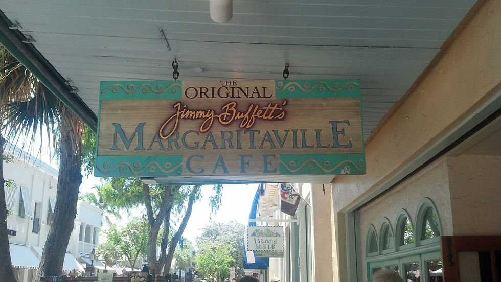
Or maybe I was just "wasting away again in Margaritaville" cafe on Duval St.

This ends our time in Key West. The third and final part of this blog series will recount our journey home.
Comments